Rivers of Hertfordshire
In The Invitation into the Country2, Pulter begins by presenting Broadfield—the estate she inhabits—as a counter-site to the turmoil of the Civil War, a secluded refuge removed from the political and existential instability that has left London bereft of its monarch. London, under the violence of the Civil War, becomes a city in mourning, a condition Pulter renders through a hydrographic poetics of grief (that is, a lament carried out through a focus on the characteristics of water); this poetics most notably surfaces in the estuarial sorrow of the Thames as it empties into the sea–a theme she also develops in The Complaint of Thames, 1647.4 But soon in the poem the pastoral tone changes, and the regional landscape is also subject to lamentation. Thus, this watery lexicon of mourning extends to the rivers of Hertfordshire, the region encircling her estate. Although these local rivers lack a direct estuarial outlet to the ocean as does the Thames, Pulter reimagines estuarial grief within this inland landscape. The Beane, Mimram, and Stort rivers pour their indignation into the river Lea, formulating a wider complaint-hydrography in Hertfordshire. In this sense, Pulter aligns herself with a broader tradition of grieving and complaining rivers in the region of Hertfordshire—figures that bear witness to historical transformation and carry the memory of both political and environmental change in the land, as famously represented in sixteenth song of Michael Drayton’s Poly-Olbion (1612).
In Poly-Olbion, Drayton formulates a chorographic epic divided into thirty songs or cantos in which he describes the natural landscape of the different regions of England and Wales. Each song is accompanied by an engraved map of the region it describes. In the case of the Hertfordshire region, where Broadfield is located, the engraving depicts the rivers Lea, Beane, Mimram, Stort, Ver, Thames, and Colne, some of which make up the riverscape of Pulter’s poem. In the map below, we can see the Thames on the left, as a main river, along with two major tributaries: the River Lea, which is fed by the Beane, Mimram, and Stort, and the River Colne, which receives the Ver. The rivers of Hertfordshire flow into the Thames, a hydrography that Pulter also deploys in her poem, as the flow and direction of their rivers is encompassed as a mourning that has movement, direction and force. Drayton’s map includes river nymphs as well as references to human settlements such as Hertford, Ware, and St. Albans, alongside the Roman ruins of “Olde Verolam” or Verulamium (which Pulter also mentions in her poem); yet the engraving, like the poem itself, remains primarily focused on the region’s natural geography, as we will explore further below.
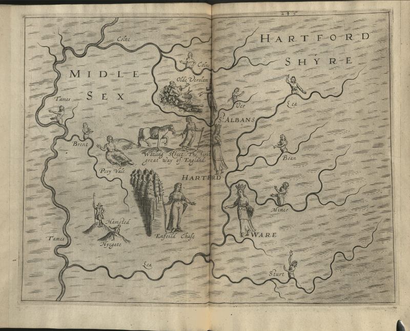
Engraving of the rivers of Hertfordshire.
Michael Drayton, Poly-Olbion (London, 1612), 245. Courtesy of the Newberry Library
In both the map and its accompanying song, the rivers Ver and Colne recall the histories of Verulamium and Watling Street—a Roman town and a Roman road, respectively—thereby inscribing a form of memory in the rivers themselves. The song then moves through Pery-Vale, a fertile region known for its wheat production, and Enfield Chase, a forested area. After traversing these landscapes, the poem introduces a second group of rivers: the Lea, Beane, Mimram, and Stort. In this section, Drayton adopts a language of kinship and harmony, as the rivers embrace and kiss the towns they pass through (such as Ware). Yet, in a movement reminiscent of Pulter, the tone of the landscape shifts when the River Lea begins to voice a complaint. She laments the state of her course, claiming she is unworthy of being seen by the village of Waltham—a settlement that also dates back to Roman times—because part of her waters were drained and diverted by King Alfred during his campaign against the Danish invasions in the ninth century. A nymph of the Stort consoles her, reminding her that all things are subject to change, a consolation that continues until the River Lea joins the Thames. In this way, Drayton renders rivers as witnesses of historical transformation—both metaphorically, through their personified voices, and physically, through human interventions in the landscape such as drainage and diversion.
- And that he is the hill, next Enfield which hath place,
- A forest for her pride, though titled but a chase.
- Her purlieus, and her parks, her circuit full as large,
- As some (perhaps) whose state requires a greater charge.
- Whose holts that view the East, do wistly stand to look
- Upon the winding course of Lee’s delightful brook.
- Where Mimer coming in, invites her sister Beane,
- Amongst the chalky Banks increase their mistress’ train;
- Whom by the dainty hand, obsequiously they lead
- (By Hartford gliding on, through many a pleasant Mead.
- And coming in her course, to cross the common Fare,
- For kindness she doth kiss that hospitable Ware.)
- Yet scarcely comfort Lee (alas!) so woe-begone,
- Complaining in her course, thus to herself alone;
- How should my beauty now give Waltham such delight,
- Or I poor silly brook take pleasure in her sight?
- Antiquity (for that it stands so far from view,
- And would her doting dreams should be believed for true)
- Dare loudly lie for Colne, that sometimes Ships did pass,
- To Verlam by her Stream, when Verlam famous was;
- But, by these later times, suspected but to feign,
- She planks and anchors shows, her error to maintain;
- Which were, indeed, of boats, for pleasure there to row
- Upon her (then a lake) the Roman pomp to show,
- When Rome her forces here did every year supply,
- And at old Verlam kept a warlike colony.
- But I distressed Lee, whose course doth plainly tell,
- That what of Colne is said, of me none could refell,
- Whom Alfred but too wise (poor river) I may say
- (When he the cruel Danes, did cunningly betray,
- Which Hartford then besieged, whose navy there abode,
- And on my spacious breast, before the castle rode)
- By vantage of my soil, he did divide my stream
- That they might never return to Neptune’s watery Realm.
- And, since, distressed Lee I have been left forlorn
- A by-word to each brook, and to the world a scorn.
- When Sturt, a Nymph of hers (whose faith she oft had proved,
- And whom, of all her train, Lee most entirely loved)
- Lest so excessive grief, her mistress might invade,
- Thus (by fair gentle speech) to patience doth persuade:
- Though you be not so great to others as before,
- Yet not a jot for that dislike yourself the more.
- Your case is not alone, nor is (at all) so strange;
- Sith everything on earth subjects itself to change.
- Where rivers sometime ran, is firm and certain ground:
- And where before were hills, now standing lakes are found.
- And that which most you urge your beauty to despoil,
- Doth recompense your bank, with quantity of soil,
- Beset with ranks of swans that, in their wonted pride,
- Do prune their snowy plumes upon your pleasant side.
- And Waltham woos you still, and smiles with wonted cheer:
- And Thames as at the first, so still doth hold you dear.
- To much beloved Lee, this scarcely Sturt had spoke,
- But goodly London’s sight their further purpose broke:
- When Thames his either Banks, adorned with buildings fair,
- The City to salute doth bid the Muse prepare.
While the map of Hertfordshire in Poly-Olbion emphasizes natural geography—highlighting rivers and forests with human personifications and only a few settlements—Christopher Saxton’s Atlas of England and Wales (1579), the first comprehensive atlas of the region, offers a complementary perspective. His hand-colored map (below) includes natural features but places greater emphasis on human settlements. Zooming in, we can observe the vivid blue used to depict the region’s rivers, along with the location of Pulter’s Broadfield (spelled “Bradfeld” on the map).
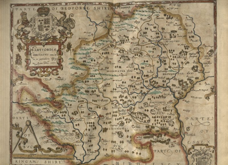
Map of Hertfordshire with the regional rivers.
Christopher Saxton, An atlas of England and Wales (London, 1579), map 9. Courtesy of the Newberry Library.
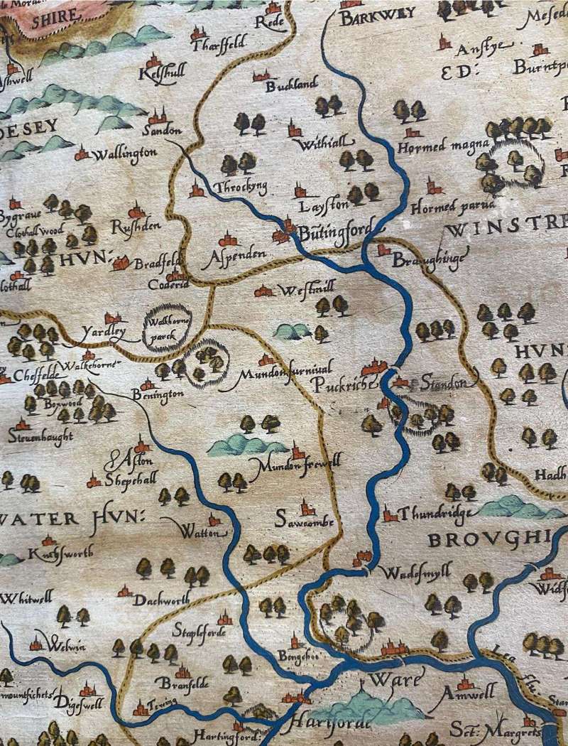
Detail of the map of Hertfordshire showing the surroundings of Broadfield.
Christopher Saxton, An atlas of England and Wales (London, 1579), map 9. Courtesy of the Newberry Library.
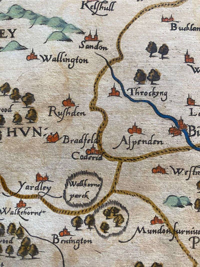
Detail of Broadfield (“Bradfeld”) in the map of Hertfordshire.
Christopher Saxton, An atlas of England and Wales (London, 1579), map 9. Courtesy of the Newberry Library.
The region of Hertfordshire is surrounded by rivers, as shown in the maps of Drayton and Saxton. These rivers inhabited Pulter’s imagination and shaped her sense of the land she lived in as an adult. For Pulter, rivers are not passive elements of the landscape, but living beings who actively participate in the political realities of England during the Civil War period. In this sense, both Drayton and Pulter articulate a poetics rooted in the specificities of Hertfordshire’s rivers, construing them as conduits of national culture and as bearers of historical memory and contemporary experience. The rivers’ flows transmit narratives from the distant past and the present, which the poets interlace to establish a dynamic relationship between water and the imagining of the nation; they are living agents capable of lamenting political and environmental conditions.